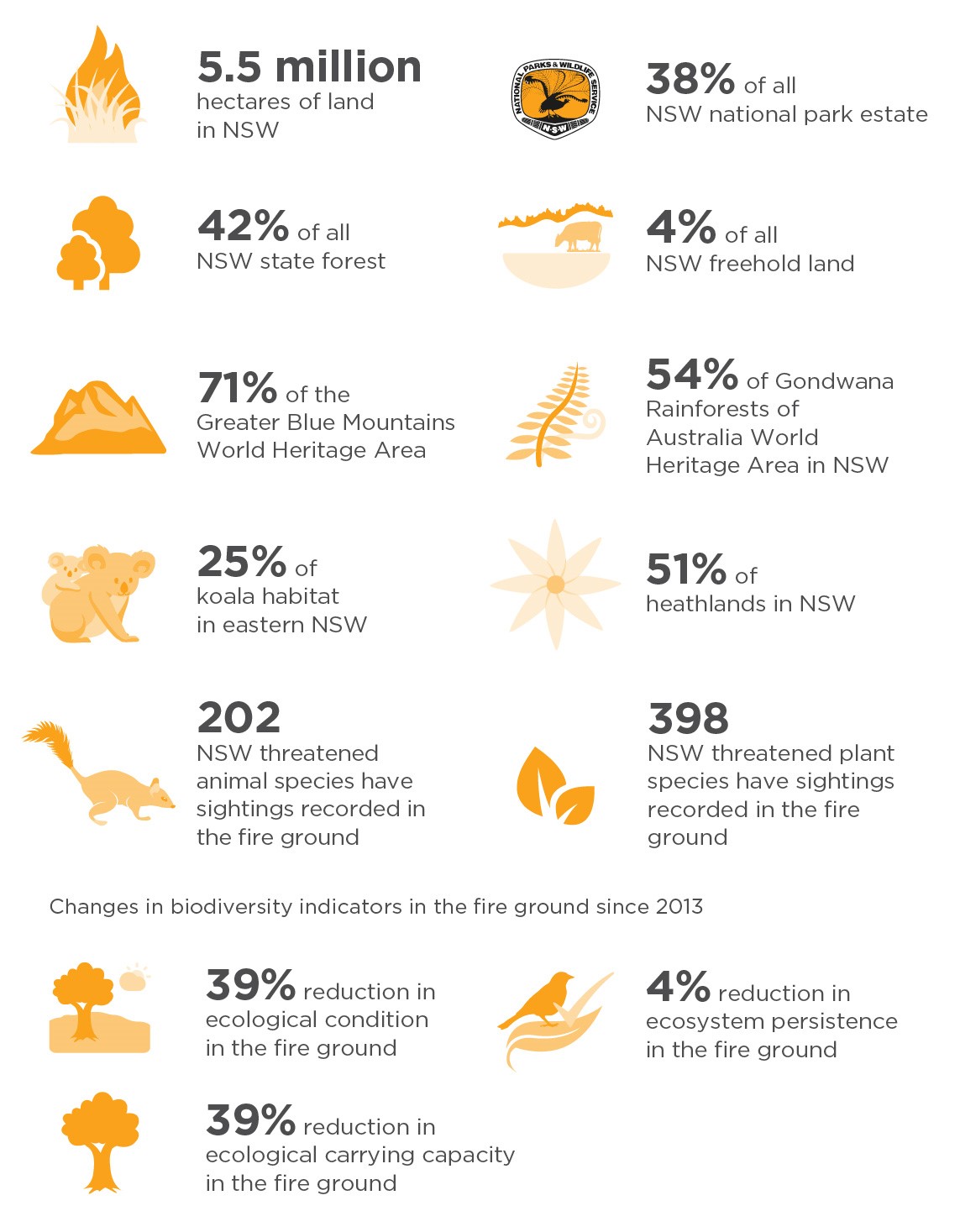
The 2019–20 bushfires were unprecedented in their extent and intensity, with fire grounds in New South Wales covering 5.5 million hectares (7% of the state), including over 2.7 million hectares of national parks (38% of the NSW national park system).
Our scientists have been collecting information since the fires began. Though the fire events are over, the science of understanding what happened is still going. We will be doing post-fire assessments for many years to come to fully understand the effects of the 2019–20 fires. This will enable us monitor recovery and renewal to ensure that decisions are informed by the best possible science.
Our data and information are shared across emergency response agencies, including the NSW Rural Fire Service (RFS), and with environmental organisations to support conservation decisions and on-ground actions.
As more data comes through about the fire events, we update and refine bushfire related datasets to inform conservation actions being taken. These are published as part of our NSW Government response plan. The data sets are also published on our Sharing and Enabling Environmental Data Portal (SEED) 'Bushfire related datasets' page.
Our research
Below is an outline of the documents that we have published from most recent to when the fires first began:
- January 2021 – The NSW Wildlife and Conservation Bushfire Recovery: Medium-term response plan was published. The plan outlines actions that will be taken over the next 5 years to support the recovery of biodiversity in New South Wales following the 2019–20 fires. It includes updated data and assessments and is the most up-to date document about our response to the 2019–20 fires.
- November 2020 – The Air quality special statement spring–summer 2019–20 was published to provide a comprehensive analysis of the air quality during the 2019–20 fires.
- May 2020 – The Fire and the Environment 2019–20 Summary was published, which included all available data from our scientists' rapid assessments, an update to data included in the immediate response.
- January 2020 – The Wildlife and Conservation Bushfire Recovery: Immediate Response January 2020 was published, describing the NSW Government's early response to the bushfires. It provided a snapshot of the extent and severity of fire damage across the state, based on immediate assessments.
This page will continue to be updated with relevant data as it becomes available.
Effects of the fires on our environment
The NSW Wildlife and Conservation Bushfire Recovery: Medium-term response plan was published January 2021. The plan outlines actions that will be taken over the next 5 years to support the recovery of biodiversity in New South Wales following the 2019–20 fires.
The plan is supported by 2 companion documents:
- Supplement A: Assessing the impacts of the bushfires on wildlife and conservation.
- Supplement B: A report on the Immediate Response.
Supplement A provides the latest information on the extent and severity of the fires and details the findings of conservation assessments undertaken on fauna, flora and ecological communities in New South Wales.
Key findings
Immediately after the fires, our assessments estimated that there were 293 priority animal species and 680 priority plant species. These assessments used sighting records from our BioNet database only, as we couldn't safely enter the fire grounds to do field assessments and observations.
Since then, scientists have been able to go into the fire ground to see the effects of the fires and observe what species were doing after the fires. This has enabled us to refine our datasets and update our estimates to better reflect what is happening on the ground.
The most notable change relates to the percentage of the Greater Blue Mountains World Heritage Area. Rapid assessments in mid-2020 estimated 81% to be affected. Since then, our on-ground assessments estimate that 71% of the area is impacted.
The number of 'priority' threatened animal and plant species with sighting records within the fire ground has also reduced. In the immediate response, species were categorised as 'priority' if sighting records for the species overlapped with areas where the canopy and understorey were considered burnt, through remote fire mapping and modelling. These assessments are being refined through field assessments and observations.
Our current assessments estimate:
- 202 priority threatened animal species
- 398 priority threatened plant species.
Refined assessments are showing more than 25% of the most suitable koala habitat in eastern New South Wales was within fire-affected areas.
As post-fire assessments continue, we are waiting to see how landscapes respond after the fires. It takes time to see how animals and plants are responding, e.g. whether animals left an area and are now returning. We will continue to update our data as we complete more assessments, always using the most rigorous science available to inform our conservation decisions. It is also important to note that positive outcomes of species and ecosystems will occur in places through natural renewal processes.
A rapid assessment of post-fire analyses mapping fire extent and environmental and landscape values was published in the NSW Fire and the Environment 2019–20 Summary. The summary used 3 February 2020 data on the extent of the fire ground as mapped by the Rural Fire Service and relative fire severity to provide a rapid assessment of how the fires have affected biodiversity and landscape metrics.
The summary captured the immediately known effects of the 2019–20 fires on a number of key biodiversity values and reports on changes in indicators from the Biodiversity Indicator Program. It is a companion document for the Biodiversity Outlook Report, also released in May 2020.
When reporting on the effects of fire in NSW national parks, calculations include gazetted national parks, nature reserves, state conservation areas, Aboriginal areas, historic sites, regional parks and karst reserves (a total of 878 parks).
Based on the data we currently have which considers the relative severity and extent of fires within the fire ground identified by the RFS:
- A total of 5.4 million hectares (7%) of New South Wales have been affected by the fires. The severity of fire within this total area varies.
- A total of 37% of the national park estate has been affected.
- More than 81% of the World Heritage listed Greater Blue Mountains Area and 54% of the NSW components of the Gondwana Rainforests of Australia World Heritage property have been affected by fire.
- The most affected ecosystems are rainforests (37% of their statewide extent), wet sclerophyll forests (50%) and heathlands (52%).
The locations of more than 293 threatened animals have been affected by the fires as of 3 February 2020. Of these animals:
- 99 animal species have more than 10% of their recorded locations within the fire ground
- 5 animals have more than 80% of their records within the fire extent.
Many individual national parks have been seriously affected. As of 3 February 2020:
- 57 parks or reserves have had more than 99% of their area affected by fire (near complete)
- 73 parks or reserves have 75% to 99% of their area affected (majority)
- 31 parks or reserves have 50% to 74% of their area affected (extensive)
- of the remaining parks affected by fire, 84 have less than 50% of their area affected (partial).
This table (current as of April 2020) provides an indication of the effects of the fires on major vegetation types.
| Vegetation formation | Total fire affected (ha) | Total in NSW (ha) | % |
|---|---|---|---|
| Heathlands | 102,969 | 191,599 | 53.74 |
| Wet sclerophyll forests (grassy sub-formation) | 1,147,486 | 2,239,619 | 51.24 |
| Wet sclerophyll forests (shrubby sub-formation) | 647,612 | 1,326,569 | 48.81 |
| Rainforests | 305,690 | 820,471 | 37.26 |
| Dry sclerophyll forests (shrub/grass sub-formation) | 880,973 | 2,860,372 | 30.80 |
| Dry sclerophyll forests (shrubby sub-formation) | 1,520,489 | 5,234,211 | 29.05 |
| Alpine complex | 27,410 | 130,791 | 20.96 |
| Forested wetlands | 93,140 | 1,115,592 | 8.35 |
| Grassy woodlands | 221,595 | 3,881,087 | 5.71 |
| Freshwater wetlands | 47,739 | 2,310,619 | 2.07 |
The NSW Wildlife and Conservation Bushfire Recovery: Medium-term response plan is the leading document informing the NSW Government's planned actions as of January 2021.
'Supplement A – Assessing the impact of the bushfires on wildlife and conservation' details the findings of conservation assessments undertaken on animals, plants and ecological communities in New South Wales. It supersedes the animal and plant assessments in the NSW Fire and the Environment 2019–20 Summary, released in May 2020, which also captured the effects on other biodiversity values, including changes in indicators from the Biodiversity Indicator Program.
More information about air quality during the fires can be found in our Air quality special statement spring-summer 2019–20. This statement also details actions taken during the season and actions we are taking to continue improving our data delivery services, air quality monitoring, modelling and forecasting.
How our science is helping recovery
We are helping on-ground conservation actions be as effective and impactful as possible by providing information on which areas need priority support and advice on what actions will be the most beneficial for recovery efforts.
You can read more about specific on-ground actions, such as the supplementary food drops to support brush-tailed rock-wallabies, as well as how you can help with recovery efforts on our Recovering from the 2019–20 fires webpage.
To help prioritise ongoing conservation and recovery actions in New South Wales following the 2019–20 bushfires, we’ve compiled a list of priority NSW plants for field assessment. This is the first step in quantifying the impacts of the fires on our native plants and ensuring effective management actions to support natural recovery and long-term population persistence.
The species listed in Priority NSW plants for post-fire field assessment will be updated as field assessments are completed and more information on impacts, threats and natural regeneration comes in. Updated lists will be published to this page periodically with previous versions publicly archived for reference.
While bushfires (even intense ones) are part of a natural cycle in the bush, an unprecedented combination of threats means that natural post-fire recovery may not occur for some species. The Priority NSW plants for post-fire field assessment as at 18 November 2020 targets those plant species at high risk from multiple threats, beyond the range of those they may have previously coped with.
The identified priority species come from an analysis of those in the Australian Government's Final national prioritisation of Australian plants affected by the 2019–2020 bushfire season (PDF 2.8MB) (Gallagher 2020) and the Preliminary assessment of impacts of the 2019–2020 bushfires on NSW plants of national significance (Auld et al. 2020 and subsequent revisions).
It is worth noting that most plant species in New South Wales are expected to fully recover following the 2019–20 fires. This is because fire plays an important role in maintaining the populations of many plants.
Fire promotes germination in many species through the release of canopy-stored seeds (as in many Banksia and Eucalyptus species), and it stimulates germination of many seeds stored in the soil. Some species even require hot fires to break seed dormancy, including many wattles (Acacia spp.) and native peas (species in the Fabaceae family).
Other species are stimulated to flower after fire, such as grass trees (Xanthorrhoea), Gymea lilies (Doryanthes) and Christmas bells (Blandfordia). However, fires can lead to species decline if they:
- occur out of season
- are too frequent
- happen when plants are stressed by drought, for example
- burn sensitive and ill-adapted species (such as some rainforest plants).
To identify the NSW plant species at greatest risk, we looked at the proportion of each species’ national range estimated to have been burnt along with plant traits known to affect post-fire recovery, including:
- growth form – for example, tree, shrub or herb
- fire response type – that is, plants that resprout following fire versus those that are killed by fire and depend on seeds to recover at a site
- seed bank type – that is, canopy/soil-stored, short/long-lived or none
- sensitivity to fire, including high-severity fire.
These data were then assessed against the presence of a range of interacting threats that may cause decline or local extinction on their own (for example, grazing by introduced animals such as goats) and could be devastating in combination with fire impacts (refer to Appendix 1 of Auld et al. 2020 for specific details of the risk prioritisation framework).
The factors considered in the risk analysis were:
- species’ life histories
- plant sensitivity to fire
- fire regimes and how these impacts species’ life histories and persistence
- high fire frequency – where the 2019–20 bushfires have burnt over populations still recovering from previous fires
- high fire severity – high fire severity is associated with low survival rates in functionally important groups of plants and animals in many ecosystem types
- cumulative exposure to high risks of decline – where the 2019–20 fires have contributed to a large proportion of the total population being in a recovering/immature state and thus vulnerable to future fires
- environmental variables and their impacts on plant survival, fecundity and recruitment
- interactive effects of fire and drought
- post-fire erosion
- elevated winter temperatures or changed temperature regimes affecting post-fire germination and recovery
- post-fire threats to plant recovery
- impacts from introduced herbivores – for example, pigs, horses, deer, rabbits and stock
- fire-disease interactions
- weed invasion
- other threats such as vehicular disturbance, trampling, illegal collection, mining, logging and altered hydrological regimes (among others).
This work will be used to help guide conservation actions and focus efforts on the species most at-risk of decline or local extinction.
References
Auld TD, Mackenzie BDE, Le Breton T, Keith DA, Ooi MKJ, Allen S, Gallagher RV 2020, A preliminary assessment of the impact of the 2019–2020 fires on NSW plants of national significance, Report to the NSW Department of Climate Change, Energy, the Environment and Water.
Gallagher RV 2020, Final national prioritisation of Australian plants affected by the 2019–2020 bushfire season, Report to the Commonwealth Department of Agriculture, Water and Environment.
Fire changes the physical and chemical composition of soil and how it functions. After a fire, there is a higher risk of large-scale erosion events because of reduced ground cover, increased runoff and flood events. Erosion events are a widespread natural hazard, but the frequency and severity of erosion after a fire can cause excessive effects on the quality of land and water.
Building on research and outputs from the Warrumbungle soil and water recovery project, we have developed a hillslope sheet erosion modelling tool to help understand the potential for erosion events and what the impact of these events will be after a fire has been in the area.
More information about hillslope sheet erosion modelling can be found in our Soil hillslope erosion modelling factsheet and data is accessible through the Sharing and Enabling Environmental Data (SEED) portal.
We also refer to our Soil and Land Information System (SALIS), which contains descriptions of soils, landscapes and other geographic features. This gives information about what soils were like before fire so we can understand how they have changed after fire. This information helps inform conservation and remediation decision making. Data from SALIS is accessible online through eSPADE, which provides soil information for all of New South Wales.
eSPADE is accessible online through the Sharing and Enabling Environmental Data (SEED) portal.
NSW streams and coastal waterways have evolved in a landscape characterised by a regime of relatively low-intensity, mosaic fires which may periodically modify the delivery of sediments, carbon types and nutrients during runoff events.
The scale and intensity of the 2019–20 fires were unprecedented, giving rise to concerns about potential changes to hydrology and pollutant generation from fire grounds and the downstream effects on receiving waters that are outside the expected natural variation. Loss of vegetation near waterways, soil erosion, falling ash and changes to the water flows can all have an impact.
It takes time to fully understand these impacts of fire events on water quality. Burnt leaves and branches that wash into waterways break down over time, using up oxygen from the water column which supports fish, oysters and other aquatic species.
Throughout 2020 our scientists – together with the NSW EPA, the Department of Climate Change, Energy, the Environment and Water's South East Regional Water Floodplains and Coastal Team, the Department of Regional NSW Marine Parks officers and local government – carried out sampling in a number of fire-affected catchments that are at very high risk for water quality impacts.
Our scientists are also collaborating with a number of universities in developing and carrying out targeted research programs that assess the impact on the ecosystem function and structure of estuaries with fire-affected catchments. More information about what our scientists were doing in immediate response to the fires to address water quality concerns can be found in our Water quality science in response to the NSW bushfire emergency fact sheet.
One of the biggest concerns for water quality after a fire is heavy rain. After a fire, it is likely that there will be increased water runoff, which can lead to erosion and flooding. The runoff carries soil, leaves, ash and other burnt organic debris with it into waterways, and this has an immediate effect on water quality.
An interim dataset of water quality following the heavy rainfall in February 2020 in 18 south coast waterways is available on SEED. As more data becomes available, and following a comprehensive laboratory analysis, this dataset will be updated and available through SEED.
To help measure changes as a result of the 2019–20 fires, we've added more monitoring indicators to the statewide water quality monitoring program to further understand the effects on water quality and ecological health. This program is part of the NSW Marine Estate Management Strategy and will continue to assist in tracking the condition of waterways and the effects of bushfire and other pressures on water quality across New South Wales.
Routine monitoring to assess long-term impacts following fire is being carried out in Wonboyn River. Rainfall event-based monitoring was carried out in Tuross River, Clyde River, Shoalhaven River, Conjola Lake, Termeil Lake, Meroo Lake and Durras Lake following the big rainfall events that affected the NSW coast in February, July and August of 2020.
Water quality is monitored in the field for salinity, temperature, dissolved oxygen and turbidity. Water samples are also collected for further analysis at our environmental forensics' laboratory. These samples are being tested for nutrients, total suspended solids, trace metals and organic pollutants. The data from this monitoring is available on SEED.
This monitoring is helping provide vital information to determine how the combination of a bushfire-affected landscape and heavy rainfall, effects the community and environmental values of estuaries. These values include recreational use, visual amenity, health of aquatic ecosystems, fishing activities and aquaculture.
Our scientists have worked closely with Shoalhaven City Council, Eurobodalla Shire Council and Bega Valley Shire Council to design and implement long-term water quality monitoring programs to assess the impacts of fires on aquatic ecosystem health in estuaries and assist in developing management actions to minimise any impacts.
In 2021, our scientists will start targeted research to enhance our understanding of how bushfires impact water quality and ecological health of estuaries and freshwater streams and develop a range of tools to inform management responses to mitigate potential impacts.
Information about the severity of a fire on a landscape is critical to understanding the relationship between fuels, fire behaviour and landscapes. Our scientists have been working with the NSW Rural Fire Service (RFS) since 2018 to develop fire extent and severity maps, and the data and maps for the recent 2019–20 fires have just been released on the Sharing and Enabling Environmental Data (SEED).
Immediate assessments of the effects and impacts of the fires were based on rapidly produced maps using the Burnt Area Map (based on Google Earth satellite imagery). These broad scale maps predicted how severely the canopy was burnt by measuring the change in the colour of vegetation after a fire. Being able to provide rapid assessments was important during the fires to support on-ground conservation decision making and actions.
To support conservation actions and understand the full effects of the fires, the more refined data from the fire extent and severity maps is used. Ongoing and future assessments will be based in the fire extent and severity maps.
The fire extent and severity maps give an understanding of how a fire has changed the landscape at a detailed level. It provides information about the damage fires have caused to tree canopy and understory, and how far each fire spreads.
Fire extent and severity map is a mapping system that uses satellite imagery and machine learning to deliver timely maps. This then enables areas to be classified into standard 'fire severity' classes to help researchers understand how the fires have affected the landscape and inform on-ground conservation actions.
It is a semi-standardised, automated remote sensing approach that can support fire management planning. Scientists from our Remote Sensing and Landscape Science Branch worked with the NSW Rural Fire Service and other organisations in the NSW Bushfire Risk Management Research Hub to develop the maps.
Our biggest challenge moving forward for fire management is that most of our forest landscapes are now set to the same timeline of 2019–20 since the time of the last fire. This is a risk for environmental management as we have lost diversity in our fire regimes with large swathes of bush recovering at one time.
More information can be found in our Supporting fire management with the Fire Extent and Severity Maps fact sheet, and you can download a data package for offline use.
The loss of ground cover and vegetation combined with the effects of drought increases the likelihood of dust storms. These affect the health of NSW communities and pose significant challenges for natural resource management.
We work with volunteers across New South Wales and other states to run the Rural Air Quality Monitoring Network (RAQMN). There are 35 volunteer-operated sites within New South Wales, supported by 6 sites outside of New South Wales to give early warning for when dust events are moving into the state. The data from these sites contribute to the DustWatch program.
Find out more on our Community DustWatch page.
More information about how we monitor for dust can be found in our Monitoring for dust events fact sheet.
Air pollution has a significant impact on human health and the economy. We operate the most comprehensive air quality monitoring network in Australia, providing information on air quality in near real-time across the state. The network is continually reviewed and assessed.
Air quality in New South Wales is usually very good by international standards. We have created the air quality categories (AQC) rating scale to help us understand how clean or polluted the air is across New South Wales and how current air quality might affect your health. This enables you to protect your health during poor air quality events. The AQC is updated hourly, and you can view this on the Department of Climate Change, Energy, the Environment and Water's Air quality concentration data – updated hourly webpage.
To find more information about the AQC, visit the department's Understanding air quality data webpage.
The frequency and severity of poor air quality events increases during fires because of smoke, ash and other airborne particles.
The NSW Government has established an air pollution emergency monitoring response capability for incidents lasting several days to many months. An emergency air quality monitoring station may be established within 24 to 48 hours of receiving a request from a leading emergency response agency. The capability has been deployed in response to multiple incidents since 2017, including the Chullora recycling station fire in 2017 and the Kooragang Island Waste Emplacement Facility underground fire in February to June 2019.
Nine emergency monitoring stations were deployed during the 2019–20 bushfires, streaming continuous data to the public. After the fires were extinguished in early February 2020, the deployments continued for an additional 6 weeks to collect further data on background air pollution.
As part of the regular network-review process, the stations at Cooma, Grafton, Lismore, and Merimbula were retained and integrated with the Rural Air Quality Monitoring Network. More information about this monitoring can be found in our Emergency incident air quality monitoring fact sheet.
More information
- Wildlife and conservation bushfire recovery: Medium-term response
- Emergency air quality monitoring in response to bushfires
- Google Earth Engine Burnt Area Map
- Impact of fires on plants and animals
- Monitoring for dust events
- Soil hillslope erosion modelling
- Water modelling and monitoring
- Air quality special statement spring-summer 2019–20