In the Lachlan catchment, water for the environment was used to provide a series of flows throughout the year targeting the full length of the Lachlan River, including the Great Cumbung Swamp, the Booberoi Creek anabranch system, Lake Brewster outflow wetlands, and several small private wetland waterings. This:
- provided benefits for native fish populations, including the first pre-emptive use of the water quality allowance to avoid fish kills during record heat and blue-green algal outbreaks
- delivered pulses of water into anabranch creeks, increasing connectivity
- supported successful wetland plant (aquatic macrophyte) establishment
- supported riparian and wetland vegetation in the lower Lachlan, including core reed beds in the Great Cumbung Swamp
- provided roosting and foraging habitats for water birds in the lower Lachlan
- stimulated the aquatic food web along the length of the Lachlan River
- provided opportunities to partner with the mid-Lachlan Aboriginal community and Ngiyampaa Nation to support and access the cultural values and practices of Booberoi Creek.
The Bureau of Meteorology reported 2018–19 as Australia’s hottest summer on record. In the Lachlan catchment, low rainfall accompanied the record heat of summer, with no notable inflow into Wyangala Dam and no new available water determination since August 2017. Water used was carried over in accounts from the 2016 flooding, with Wyangala Dam starting the water year at around 60% and finishing at 29%.
Watering aims
The Lachlan catchment began the 2018–19 year with access to carried-over water allocations, which was enough (>50% available in general security accounts) to trigger the Wyangala and Lake Brewster environmental water allowances (EWAs) under the Water Sharing Plan for the Lachlan Regulated River Water Source 2016. However, the Lake Brewster EWA was unable to be accessed throughout the year because Lake Brewster storage remained effectively empty. The water quality allowance was available from 1 July 2018.
With hot, dry weather and below average rainfall forecast, the Department of Planning, Industry and Environment – Environment, Energy and Science’s (DPIE–EES) Water for the Environment Team worked with the community-based Lachlan Environmental Water Advisory Group (EWAG) to determine short- and long-term priorities for use of available water holdings.
Priorities identified for water deliveries were to:
- protect and enhance native fish populations within the river system by providing a range of flows, from maintaining baseflows and providing smaller and larger ‘freshes’ (a fresh is a pulse of water that provides access to habitat and encourages fish to move); and to prevent major drops in river heights during nesting periods to support breeding, provide food, improve habitat, and encourage movement
- manage water levels in the Lake Brewster outflow wetlands to support water plant (macrophytes) establishment and seed setting, water quality and waterbirds
- support identified cultural values and practices and active participation of the Aboriginal community and Lachlan EWAG members to plan and monitor watering events
- provide off-river and floodplain wetland roosting and a range of foraging habitats for water birds
- plan targeted flows for the length of the river to ensure the release of nutrients throughout the system, boost the aquatic food web, support wetland plants and animals including river red gums, black box, and waterbirds.
With the forecast hot, dry weather towards the end of the water year, we focused on building resilience into refuge sites to sustain and maintain species and help future recovery.
Water delivery
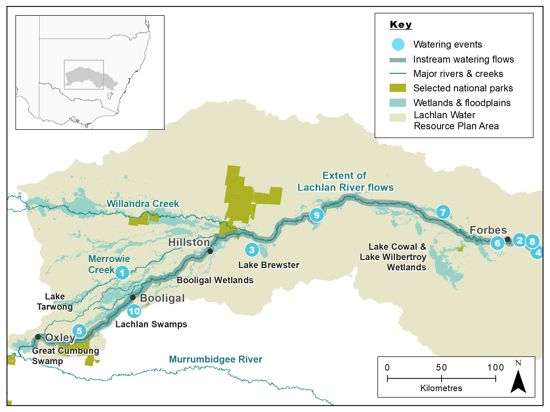
This table provides a summary of water for the environment use in the Lachlan catchment during the 2018–19 watering year. Volumes are indicative only.
Notes: Location numbers in the table relate to watering events marked on the map.
NSW = NSW licensed environmental water; CEW = Commonwealth licensed environmental water; EWA = Environmental water allowance accrued under the Water Sharing Plan for the Lachlan Regulated River Water Source 2016.
| Watering event number | Location | Start date | Finish date | NSW | CEW | EWA | Total |
|---|---|---|---|---|---|---|---|
| 1 | Merrowie Creek to Cuba Dam (Murphy's Lake): waterbird refugia | 21 Jul 2018 | 4 Aug 2018 | 1669 | – | – | 1669 |
| 2 | Lachlan River spring pulse: fish and productivity | 29 Aug 2018 | 15 Sep 2018 | – | 10,391 | – | 10,391 |
| 3 | Lake Brewster outflow wetlands: aquatic plants | 26 Sep 2018 | 4 Feb 2019 | 6879 | – | – | 6879 |
| 4 | Stable Lachlan River Heights: cod nesting flow | 22 Oct 2018 | 30 Oct 2018 | – | 2032 | – | 2032 |
| 5 | Noonamah black box wetland: waterbirds, frogs | 23 Oct 2018 | 29 Oct 2018 | 139 | – | – | 139 |
| 6 | Lachlan River: protecting tributary inflow | 17 Dec 2018 | 27 Dec 2018 | – | – | 5979 | 5979 |
| 7 | Burrawang West Lagoon | 18 Mar 2019 | 29 May 2019 | – | 412 | – | 412 |
| 8 | Lachlan River–Wyangala early Autumn pulse | 3 Apr 2019 | 10 Apr 2019 | – | – | 2340 | 2340 |
| 9 | Booberoi Creek winter maintenance flows: aquatic plants, fish, connectivity | 6 Jun 2019 | 30 Jun 2019 | – | – | 952 | 952 |
| 10 | Lower Lachlan winter flow (Cumbung) | 9 Jun 2019 | 28 Jun 2019 | – | 5338 | – | 5338 |
| Region | Total |
|---|---|
| NSW | 8687 |
| CEW | 18,173 |
| EWA | 9271 |
| Total | 36,131 |
Outcomes
The focus of managed watering events in the Lachlan catchment included:
- native fish
- waterbirds
- connectivity
- productivity
- source populations for aquatic plant
- Aboriginal community participation in planning and monitoring cultural and environmental outcomes.
In collaboration with WaterNSW and the Commonwealth Environmental Water Holder, the DPIE–EES Water for the Environment Team managed the delivery of 36.1 gigalitres of water across all water sources in the Lachlan valley for the environment at key times throughout the year.
Flows to support native fish began with a spring pulse, which increased water levels to inundate river benches and provided an injection of carbon and other nutrients (the building blocks of the food web) along the length of the Lachlan and its anabranches, such as Booberoi Creek. The flow provided conditions to support fish movement, nesting habitat, and cues for breeding. Learnings from delivering a similar event in the 2017–18 water year allowed the same ecological objectives to be achieved with substantially less water in 2018–19.
Monitoring of the spring pulse confirmed spawning of large numbers of small-bodied native fish, such as Australian smelt and flat-headed gudgeon and an increase in relative abundance of larval Murray cod in the lower Lachlan. Monitoring suggests the Murray cod population is recovering after hypoxic conditions in 2016, caused by natural flooding across the floodplain.
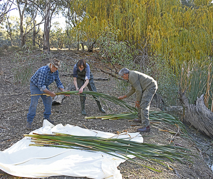
Watering events into Booberoi Creek were monitored with the local community. We worked with Booberoi water users and the Ngiyampaa Nation to protect Booberoi’s cultural and ecological values.
Booberoi Creek is a highly productive system that supports:
- turtles
- shrimp
- macroinvertebrates, for example, aquatic insect larvae such as mayflies, shrimp and dragonflies
- small- and medium-bodied native fish
- refuge habitat for freshwater catfish
- aquatic plants.
The aquatic plants of the creek are important as they can be used to help repopulate sections of the lower Lachlan.
The water release to Noonamah and Murphy’s Lake provided important large mudflat habitat that supports a number of migratory shorebirds, as well as several frog species, including southern bell frog. Most water flows helped protect the length of the Lachlan River by:
- maintaining water quality
- preventing major blue green algal outbreaks and fish kills in the Lower Lachlan
- providing inflows into the Great Cumbung Swamp
- inundating core reed beds, river red gum stands, and associated wetlands for over 6 months.
Case study
Booberoi Creek is an anabranch of the Lachlan River. Its 115-kilometre main channel feeds an array of off-channel wetlands, backwaters and oxbow lagoons. The creek system is highly productive and provides important support to the Lachlan’s aquatic food web.
In late 2018, after more than a month of no flows, Ngiyampaa Nation elder, Uncle Peter Harris, approached our team with concerns for the native fish, shrimp, water plants and overall health of the Booberoi Creek. Uncle Peter requested use of water for the environment to reconnect the creek with the Lachlan River, help remove accumulated silt, revitalise aquatic plants, and encourage movement of freshwater catfish through the system.
In response, the Lachlan Environmental Water Advisory Group (EWAG; of which Uncle Peter is a member) endorsed two small ‘fresh’ events in late December and mid-February. A fresh is a pulse of water that provides access to habitat and encourages fish to move.
We worked with members of the Ngiyampaa Nation to design the flows to achieve multiple outcomes. Members of the Murrin Bridge community helped monitor any increase in carbon and nutrients from the flows, while Booberoi Creek landholders and the Aboriginal community monitored native fish at multiple sites throughout the year. This monitoring work culminated in the Mt Boorithumble Demonstration Weekend, which brought everyone together to celebrate the Booberoi Creek’s values.
This collaboration provided the opportunity for the ecological knowledge held by Traditional Owners, the Ngiyampaa Nation, to be shared and understood by the Lachlan EWAG, the local community and DPIE–EES staff.
Another important outcome of the flows has been improved access to Country for members of the Ngiyampaa Nation, which allow the continuation of the transfer of knowledge between generations and caring for Country.