Water for the environment is managed to deliver benefits for communities and important environmental assets of the regions in which these communities live. While communities and industries face significant challenges during dry times, our rivers and wetlands also do it tough.
New South Wales is home to a unique array of native plants and animals that rely on our rivers and wetlands to survive the boom-and-bust cycles that shape the Australian landscape.
Water for the environment is a share of the water available in our dams and rivers that is managed to support the ongoing health of local waterways.
This outcomes report details our work to support river systems and meet the needs of native plants, native fish, waterbirds and other water-dependent wildlife so they can be enjoyed by all, now and into the future.
A year in the catchments
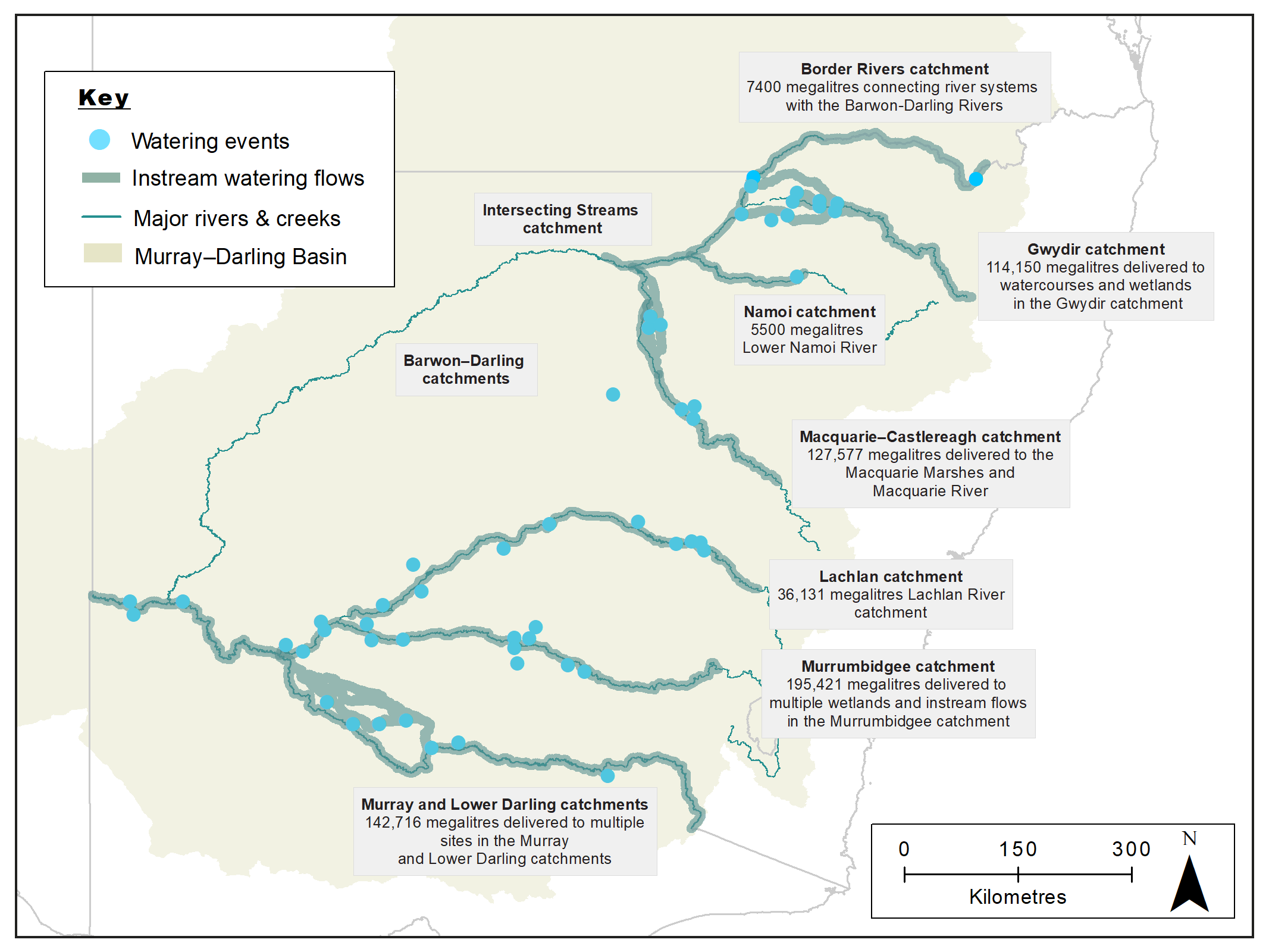
Map of New South Wales showing water catchment areas, associated main waterways and locations of water for the environment deliveries made in 2018–19.
Executive summary
Maintaining and restoring the health of rivers and wetlands for future generations is the aim of our water for the environment program. During dry times, our adaptive management approach allows us to focus our efforts on outcomes that can be achieved with reduced access to water.
In 2018–19, the Department of Planning, Industry and Environment – Environment, Energy and Science’s (DPIE–EES) Water for the Environment Team managed the delivery of water for the environment to key sites across the state. We responded to a number of rainfall events by adding water for the environment to natural inflows and enhancing outcomes for native plants and animals. This provided opportunities for native fish and waterbirds to feed and breed, plants to grow and set seed, and floodplains to release essential nutrients into the food chain.
In catchments particularly affected by dry conditions, we targeted refuge sites where native fish, waterbirds and other wildlife had congregated in and around the remaining pockets of water.
We worked with community advisory groups to prioritise the sites to receive water and build on the successes of previous years. Where possible, we also managed our water reserves to hold some water in account for future dry times.
We manage water on behalf of the NSW Government and partner with the Commonwealth Environmental Water Holder and The Living Murray (TLM) program.
Water was used strategically to:
- support habitat health
- provide essential refuge sites as the system dried down
- make subtle but important changes to river flow patterns at a number of locations to provide triggers for native fish to breed
- connect rivers with key floodplain wetlands and give native fish increased access to habitat and food.
By the end of 2018–19, water managers were again planning for dry conditions and low water availability. In consultation with community advisory groups, we put in place adaptive management plans. These plans aim to maintain critical refuge habitat and reduce the risk of irretrievable plant, animal and ecosystem losses.
Murray and Lower Darling catchments
In 2018–19 we:
- delivered 142.7 gigalitres of water to rivers, creeks and wetlands on private and public land
- worked with state and federal partner agencies to connect rivers and floodplain wetlands on a landscape scale
- triggered breeding and movement of native fish
- boosted floodplain productivity and the aquatic food web
- supported habitat health and plant growth
- partnered with a private irrigation company to upgrade and improve infrastructure which will allow increased flows and result in better outcomes for the Tuppal and Thule creeks
- delivered water to 11 private wetlands using irrigation infrastructure and private pumping to support southern bell frog populations in the central Murray.
Murrumbidgee catchment
In 2018–19 we:
- delivered 195.4 gigalitres of water to rivers, creeks and wetlands on private and public land
- connected the river with floodplain wetlands to water core sites and provide habitat for threatened species including Australian bitterns and southern bell frogs
- enhanced the resilience of wetland habitats to persist through the extended dry period
- triggered breeding and movement of native fish
- boosted floodplain productivity and the aquatic food web
- supported habitat health and plant growth
- provided critical refuge habitat for native fish, turtles and frogs at sites throughout the catchment
- averted a fish kill by providing a flush of water for the environment that improved habitat conditions for native fish and reduced the risk of rapid destratification (when layers of water mix rapidly and reduce oxygen levels in the water)
- worked with a private irrigation company to deliver water to private property wetlands supporting southern bell frogs, waterbirds and native plant life.
Lachlan catchment
In 2018–19 we:
- delivered 36.1 gigalitres of water to rivers, creeks and wetlands on private and public land
- worked with the Commonwealth Environmental Water Holder to provide a spring pulse, stabilising flow and winter flow to sections of the Lachlan River
- partnered with the mid-Lachlan Aboriginal community and Ngiyampaa Nation to support and access cultural values and practices associated with Booberoi Creek
- provided pulses of water in anabranch creeks and increased connectivity
- supported wetland plant establishment and provided roosting and foraging habitats
- boosted the aquatic food web.
Macquarie–Castlereagh catchment
In 2018–19 we:
- delivered, with the Commonwealth Environmental Water Holder, 127.6 gigalitres of water to rivers, creeks and wetlands in the catchment
- inundated 15,000 hectares of the north, south and eastern marshes vegetation to encourage seed setting
- built resilience into the semi-permanent, mixed marsh and river red gum woodlands of the Macquarie Marshes
- supported key refuge pools for native fish in the Ewenmar Creek, Nyngan lower town weir pool on the Bogan River and Macquarie River
- contributed 2.7 gigalitres to the Barwon River from a connecting flow from the lower Macquarie.
Gwydir catchment
In 2018–19 we:
- delivered with the Commonwealth Environmental Water Holder 114.2 gigalitres of water to rivers, creeks and wetlands in the catchment
- contributed to a connection flow linking the Gwydir catchment with the Barwon–Darling river system with flows extending downstream of Brewarrina Weir
- managed flows into the Mallowa Creek and wetlands to support and preserve habitat
- protected priority refuge sites in the Carole Creek, Mehi and Gwydir rivers
- provided large-scale benefits to the Gingham and Lower Gwydir wetland vegetation.
Barwon–Darling catchment
In 2018–19 we:
- partnered with the Commonwealth Environmental Water Holder to manage the release of 28.6 gigalitres of water from the environment from the Gwydir catchment to replenish pools in the Barwon River
- advised on the release of 7.4 gigalitres of Commonwealth water into the Border Rivers catchment, which replenished a section of the Barwon River downstream of Mungindi
- delivered 2.7 gigalitres from the Macquarie catchment, topping up fish refuge pools and the Brewarrina Weir
- reconnected refuge pools for native fish and other wildlife
- supported habitat health and boosted the aquatic food web
- provided connectivity and an opportunity for native fish to move and access additional habitat and food.
Border Rivers catchment
In 2018–19 we:
- advised on the delivery of 7.4 gigalitres of Commonwealth-owned water from Glenlyon Dam (Queensland Border Rivers catchment) to restore flows into the Barwon River, reconnect refuge pools, support habitat health, provide opportunities for native fish to move, refresh water quality and improve social, cultural and economic outcomes for river communities.
Namoi catchment
In 2018–19 we:
- along with the Commonwealth Environmental Water Holder, chose not to request the release of 1900 megalitres of Environmental Contingency Allowance or 477 megalitres of held water for the environment – this decision followed rainfall in the catchment that provided adequate support to native fish populations in refuge pools along the Peel River
- the Commonwealth Environmental Water Holder delivered 5.5 gigalitres of water for the environment to the Namoi River downstream of Gunidgera Weir to improve water quality and support refuge habitat for native fish survival.
Intersecting Streams catchment
In 2018–19 we:
- partnered with the National Parks and Wildlife Service and Commonwealth Environmental Water Holder to manage a flow event from the Warrego River, through Toorale Station and into the Darling River
- detected a fish recruitment event in the Warrego River as a result of the flow as a part of long-term monitoring.
Monitoring update
When water for the environment is delivered to a wetland or river it is monitored to measure the response of native plants and animals, to understand how water has moved in the landscape and the extent of inundation. Watering events are often monitored collaboratively. Government agencies work with independent researchers, tertiary institutions and community groups to gather data. The collected information is used to measure how well we are meeting long term water plan objectives and Basin Plan obligations. It also informs how we might improve future management of water for the environment.
Major themes addressed by the monitoring and evaluation program are:
- river flows and connectivity
- native vegetation
- native animals including waterbirds, frogs and turtles
- native fish.
Monitoring information is easy to access and designed to facilitate collaboration and participation across agencies and the community, thereby meeting Open Government principles.
The year in review
In the 2018–19 water year we worked closely with the Commonwealth Environmental Water Holder, community groups and independent scientists to increase our understanding of ecological responses to watering activities. An example of this collaborative approach is our work with the Gayini Nimmie-Caira Core Team, which includes members from the Nari Nari Tribal Council, University of NSW and government agencies. The team worked together to deliver and monitor water for the environment in the Gayini-Nimmie-Caira system to maintain and improve the natural and cultural values of this area.
We are also working with researchers to increase our knowledge of how water management influences the environment. Projects include:
- learning how to improve land and water management in Ramsar wetlands
- how water for the environment influences waterbird genetics.
Whole-of-NSW framework
Our coordinated monitoring evaluation and research (MER) program informs how water for the environment contributes to environmental outcomes and how we might improve the management of water for the environment to better meet long-term targets.
It provides a framework for the development of a common foundation for MER programs across New South Wales that support sound policy, planning and regulatory decision-making.
This framework also guides individual MER plans for each New South Wales basin catchment and allow us to meet Basin Plan as well as other policy and planning reporting requirements.
NSW water holdings
The Department of Planning, Industry and Environment – Environment Energy and Science (DPIE–EES) is the lead agency for the delivery of all water for the environment in New South Wales. This includes water held by the Commonwealth Environmental Water Office.
This table summarises current NSW 'held' water for the environment recovered to 30 June 2019 (megalitres).
| Valley | High security | General security | Supplementary | Unregulated | Aquifer | Total |
|---|---|---|---|---|---|---|
| Gwydir | 1249.00 | 17,092.00 | 3140.50 | – | – | 21,481.50 |
| Macquarie | – | 48,419.04 | 1451.50 | 2916.00 | – | 52,786.54 |
| Lachlan | 1795.00 | 37,595.00 | – | – | – | 39,390.00 |
| Murrumbidgee | – | 31,424.00 | 6699.96 | 9948.00 | 1847.00 | 49,918.96 |
| Lower Bidgee | – | – | 148,087.00 | – | – | 148,087.00 |
| Murray | 2027.00 | 30,157.00 | – | – | – | 32,184.00 |
| Barwon–Darling | – | – | – | 1728.00 | – | 1728.00 |
| Subtotal (DPIE–EES only) | 5071.00 | 164,687.04 | 159,378.96 | 14,592.00 | 1847.00 | 343,576.00 |
| The Living Murray | 5623.50 | 187,938.00 | 350,000.00 | 12,965.00 | – | 556,526.50 |
| Total | 10,694.50 | 352,625.04 | 509,379.96 | 27,557.00 | 1847.00 | 902,102.50 |
Water trade
Our business model allows for the periodic trading of water to cover some of the costs involved in managing the Water for the Environment Program.
Funds may also be used to purchase water or implement small-scale projects that improve the outcomes of watering events.
In 2018–19, DPIE–EES (formerly the Office of Environment and Heritage) sold 15,005 megalitres as a drought measure:
- 2900 megalitres of Gwydir allocation
- 2000 megalitres of Macquarie allocation
- 5005.5 megalitres of Lachlan allocation
- 2599 megalitres of Murrumbidgee allocation, and
- 2500 megalitres of NSW Murray allocation.
We also sold 3520 megalitres of carryover space in the Murrumbidgee.
Trade will continue in future to manage the portfolio for maximum environmental benefit.
More information about understanding water trade is available.
Partners
We work with a range of partner agencies, organisations and individuals to achieve/secure effective and efficient delivery of water to our rivers and wetlands.
These include:
- Commonwealth Environmental Water Office
- Murray–Darling Basin Authority
- Southern Connected Basin Environmental Water Committee
- Environmental Water Advisory Groups – Gwydir, Macquarie–Cudgegong, Lachlan, Murrumbidgee, Murray and Lower Darling
- Department of Planning, Industry and Environment – Water
- Department of Primary Industries – Fisheries
- Murray Lower Darling Rivers Indigenous Nations
- Northern Basin Aboriginal Nations
- recreational fishers
- landholders
- universities.
More information about some of our partner agencies is available on our terms and definitions webpage.