Water that is allocated and managed specifically to improve the health of rivers, wetlands and floodplains is known as water for the environment.
Our environmental water management teams work with local community advisory groups including landholders, Aboriginal stakeholders, partner agencies and other interested community members to develop detailed annual plans for the use of water for the environment in each catchment, including how its use is prioritised.
Water for rivers and wetlands
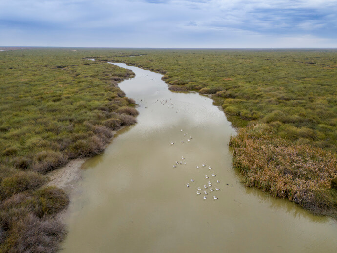
During 2023–24, the Department of Climate Change, Energy, the Environment and Water (the department) capitalised on wet conditions across the catchment to deliver water for the environment to sites including the Gayini Wetlands. The department also managed long-duration elevated base flows for cod nesting, followed by multiple instream pulses for fish dispersal in the Murrumbidgee River and Yanco Creek systems.
Water was used to benefit wetland habitats in the Murrumbidgee irrigation area and the Western Lakes.
In 2024–25, managed watering events will initially focus on maintaining permanent habitat for southern bell frogs, native fish, waterbirds (including threatened species) and other aquatic species.
Water managers plan to supplement existing system flows to provide the maximum benefit to plants and animals. Watering events will aim to restore a more natural flow pattern to support a robust food web and other system functions in the river.
Partnering with Aboriginal peoples
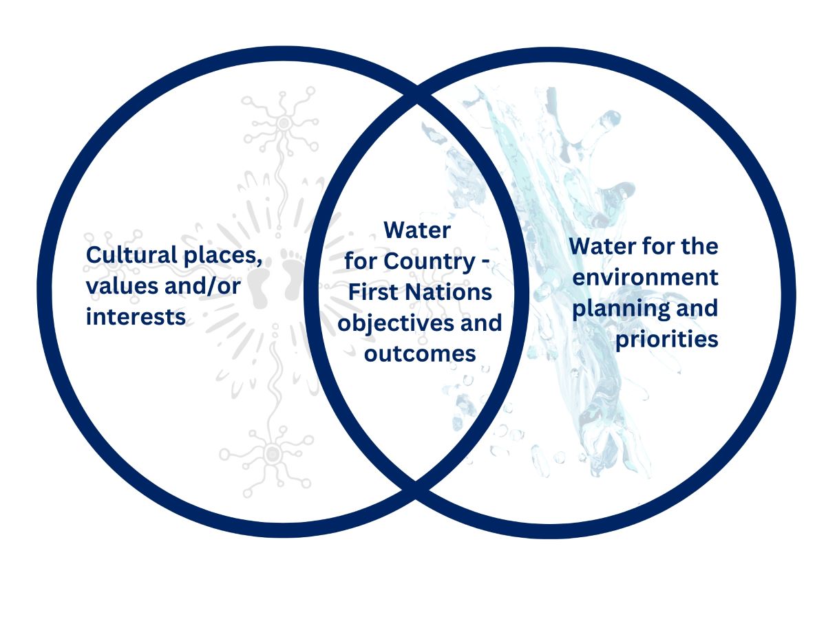
Environmental water managers have been working to support Aboriginal people’s priorities in water management.
Water for Country is environmental water use planned by the department with Aboriginal peoples to achieve shared benefits for the environment and cultural places, values and/or interests.
In 2024–25, the department will continue to engage and partner with Aboriginal groups including:
- the Nari Nari Nation, to deliver environmental and cultural outcomes with water for the environment in the Gayini and Toogimbie wetlands system
- the Mutthi Mutthi Nation, to enhance healthy Country outcomes with a view to achieving longer-term wetland and water management goals
- the Wiradjuri Nation, to develop and support land and water management with a view to longer-term co-management of numerous mid-Murrumbidgee environmental water assets.
Weather and water forecast
As of June 2024, the El Niño–Southern Oscillation outlook is neutral. That is, neither La Niña nor El Niño conditions are favoured as oceanic and atmospheric indicators have returned to neutral levels. International climate models suggest neutral El Niño–Southern Oscillation conditions will persist through the southern winter, but there are some signs that La Niña conditions could form later in the 2024–25 water year.
Indicative starting allocations are 95% for high security and 20% for general security licences. Water management plans reflect these conditions while being mindful of the numerous system constraints that will limit the scale of possible watering actions in many systems.
Water managers have prepared watering plans that consider a range of weather and water availability scenarios. This is known as resource availability scenario planning.
Resource availability scenario
This table provides details about how we plan for different resource availability scenarios. Dry conditions are forecast for the Murrumbidgee catchment in 2024–25, which means water availability planning will follow the ‘dry’ scenario.
Current forecast: Dry
| Conditions | Main aim | Other aims |
|---|---|---|
| Very dry | Protect | Avoid critical loss Maintain key refuges Avoid catastrophic events |
| Dry | Maintain | Maintain river functioning Maintain key functions of high priority wetlands |
| Moderate | Recover | Improve ecological health and resilience Improve opportunities for plants and animals to breed, move and thrive |
| Wet to very wet | Enhance | Restore key floodplain and wetland linkages Enhance opportunities for plants and animals to breed, move and thrive |
Key planned actions
Native fish
Water management plans allow for flows up to 300 gigalitres (GL) to maintain instream and deep water off-stream habitats for native fish and to restore a more natural flow pattern to support native fish populations.
Water managers will undertake opportunistic fish pulses or dispersal flows to allow young native fish and larvae to enter low-lying floodplain habitat areas, including Tala and Yanga lakes. Contingency water will be set aside to mitigate the risk of low flows and heat wave/hypoxia in the lower Murrumbidgee and mid-to-lower Yanco Billabong systems.
Waterbirds
Water managers have planned flows of up to 200 GL to provide foraging and breeding habitat for waterbirds, turtles, frogs and other aquatic species in areas including Gayini, Western Lakes and the North Redbank wetlands. Flows will water key Australasian bittern habitat in the Murrumbidgee and Coleambally irrigation areas.
Vegetation
Water managers will provide up to 10 GL of water for the environment via pumping to key mid- and lower-Murrumbidgee sites currently out of reach of river flows, including Willbriggie, Yarradda, Gooragool and Sunshower lagoons in the mid-Murrumbidgee, and Waldaira and Mainie swamps in the Junction Wetland system west of Balranald.
Connectivity
Water managers have planned flows to southern Yanga National Park via the Gayini wetland system and then south via Tala Lake, assuming reasonable starting allocations. River connectivity will be achieved by opening the Tala escape during one or more native fish pulses.
Map of proposed annual priority targets in the water resource plan area 2024–25
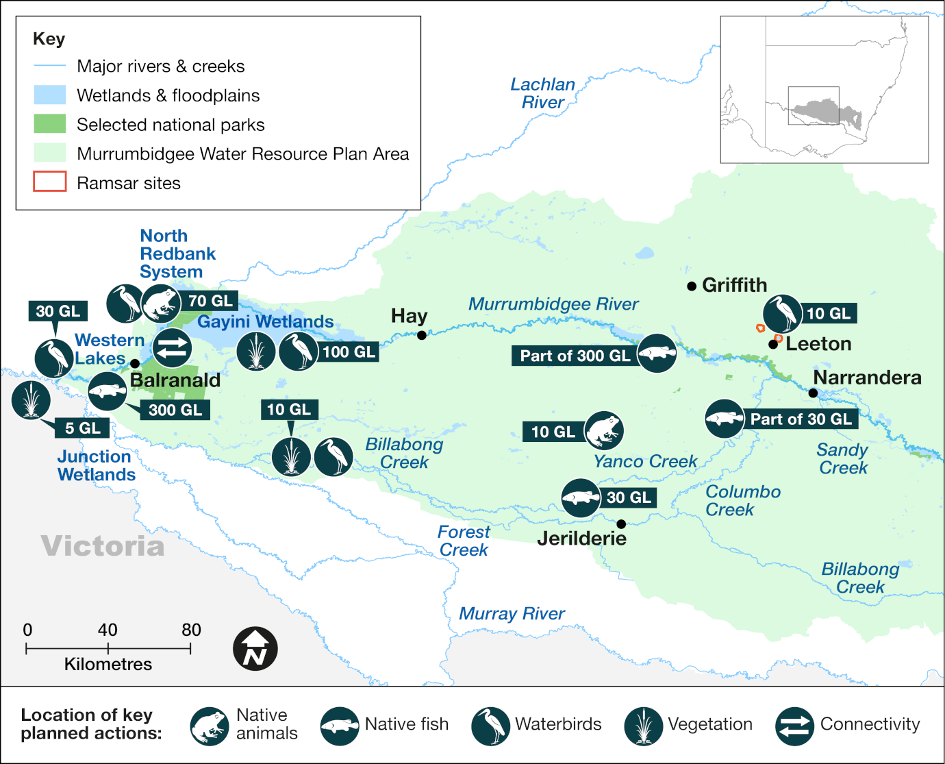
Map of the Murrumbidgee catchment area showing priority targets and volumes of environmental water to be delivered in 2024-25.
The Department of Climate Change, Energy, the Environment and Water delivers water for the environment where and when it is needed to support the health and resilience of rivers and wetlands. We use the best available science, management expertise and experience to manage water across the landscape. This statement of annual priorities identifies the waterways and wetlands that are likely to receive water.
Our decision-making process considers:
- expected availability of water in the coming year
- conditions of the previous year
- current health of the plants and animals in these ecosystems.
Water for the environment delivers benefits for communities, rivers, wetlands and wildlife across New South Wales.
Healthy, connected rivers and floodplains are a focus for tourism, fishing, recreation and relaxation.
Rivers carry water to our homes, schools, farms and businesses, and along the way, support countless species including native fish, waterbirds, frogs, plants and more. Rivers and wetlands have great cultural and spiritual significance for Aboriginal people.
Water for the environment is a critical tool to maintain and enhance the rivers, wetlands and wildlife we all love.
Working with communities
Local communities are at the heart of everything we do.
We involve the broader community by holding site tours and forums, and online and in-person events.
Our local water management teams consult regularly with community-based environmental water advisory groups.
Environmental water advisory group members include local landholders, recreational fishers, Aboriginal people and local government representatives. Their advice informs the decisions made by our local environmental water management teams.
Planned environmental water
| Source | Maximum volume available (gigalitres) | Volume expected 1 July under current conditions (gigalitres) |
|---|---|---|
| Environmental water allowance 1 | 100 | 50 |
| Environmental water allowance 2 | Triggered by Burrinjuck Dam inflows and releases | 20 |
| Environmental water allowance 3 | Linked to announced general security allocations | 0 |
Water licenced to New South Wales
| Source | Maximum volume available (gigalitres) | Volume expected 1 July under current conditions (gigalitres) |
|---|---|---|
| General security | 31.4 | 17.25 |
| Supplementary | 6.7 | Dependent on surplus flows |
| Lowbidgee supplementary access licence (South Redbank/Yanga) | 148 | Dependent on surplus flows |
Water licenced to the Commonwealth
| Source | Maximum volume available (gigalitres) | Volume expected 1 July under current conditions (gigalitres) |
|---|---|---|
| High security | 14.2 | Up to 13.5 |
| General security | 286.5 | 167.8 |
| Conveyance | 55.5 | 37.7 |
| Supplementary | 22 | Dependent on surplus flows from unregulated tributaries |
| Lowbidgee supplementary | 406.6 | Dependent on surplus flows |
NSW water licenced to The Living Murray (Murray–Darling Basin Authority)
| Source | Maximum volume available (gigalitres) | Volume expected 1 July under current conditions (gigalitres) |
|---|---|---|
| High security | 85 | 40.5 |
Notes: This is an indicative summary of expected volumes to be available. For further detail and information on available volumes you can contact the region via the Department of Climate Change, Energy, the Environment and Water on 1300 361 967.
1 gigalitre = 1000 megalitres; 2.5 megalitre = 1 Olympic swimming pool.
Water for the environment has been delivering outcomes for rivers, wetlands and wildlife for 30 years.
We deliver flows that:
- trigger native fish to breed and move
- support waterbirds to nest and feed
- connect rivers and floodplains
- water forests and floodplains
- allow plants to grow, flower and set seed
- create refuge during droughts
- enhance outcomes during wetter times
- release vital nutrients from the floodplain floor that underpin the aquatic food web.
It’s habitat restoration on a landscape scale.
The Murrumbidgee river is one of Australia’s most regulated river systems.
More information on planned and past watering events
- Annual environmental water priorities in the Murrumbidgee catchment 2023–24
- Annual environmental water priorities in the Murrumbidgee catchment 2022–23
- Murrumbidgee Catchment – Water for the Environment: Annual Priorities 2021–22
- Murrumbidgee catchment: Annual environmental watering priorities 2020-21
- Water for environment outcomes 2022-23
- Water for environment outcomes 2021-22
- Use of water for the environment in NSW: Outcomes 2020–21