
Water for the environment is managed to deliver benefits for communities and important environmental assets across New South Wales.
During periods of higher rainfall, we adapt our planning to ensure rivers and wetlands can maximise the opportunity to recover and increase their resilience for future dry times. Water for the environment use is high because the need for natural processes to run their course is also high.
New South Wales is home to a unique array of native plants and animals that rely on our rivers and wetlands to survive the boom and bust cycles that shape the Australian landscape.
Since river regulation, our rivers and floodplains connect less often than is needed to remain healthy.
Water for the environment is the best available tool that allows us to support the ongoing health of local waterways along with the native plants, animals and local communities that rely on them.
Water for the environment is delivering habitat restoration on a landscape scale.
The Department of Planning and Environment (DPE) is responsible for ensuring that water for the environment is managed in accordance with relevant statutory plans, including water sharing plans established under the NSW Water Management Act 2000 and the Basin Plan established under the Commonwealth Water Act 2007.
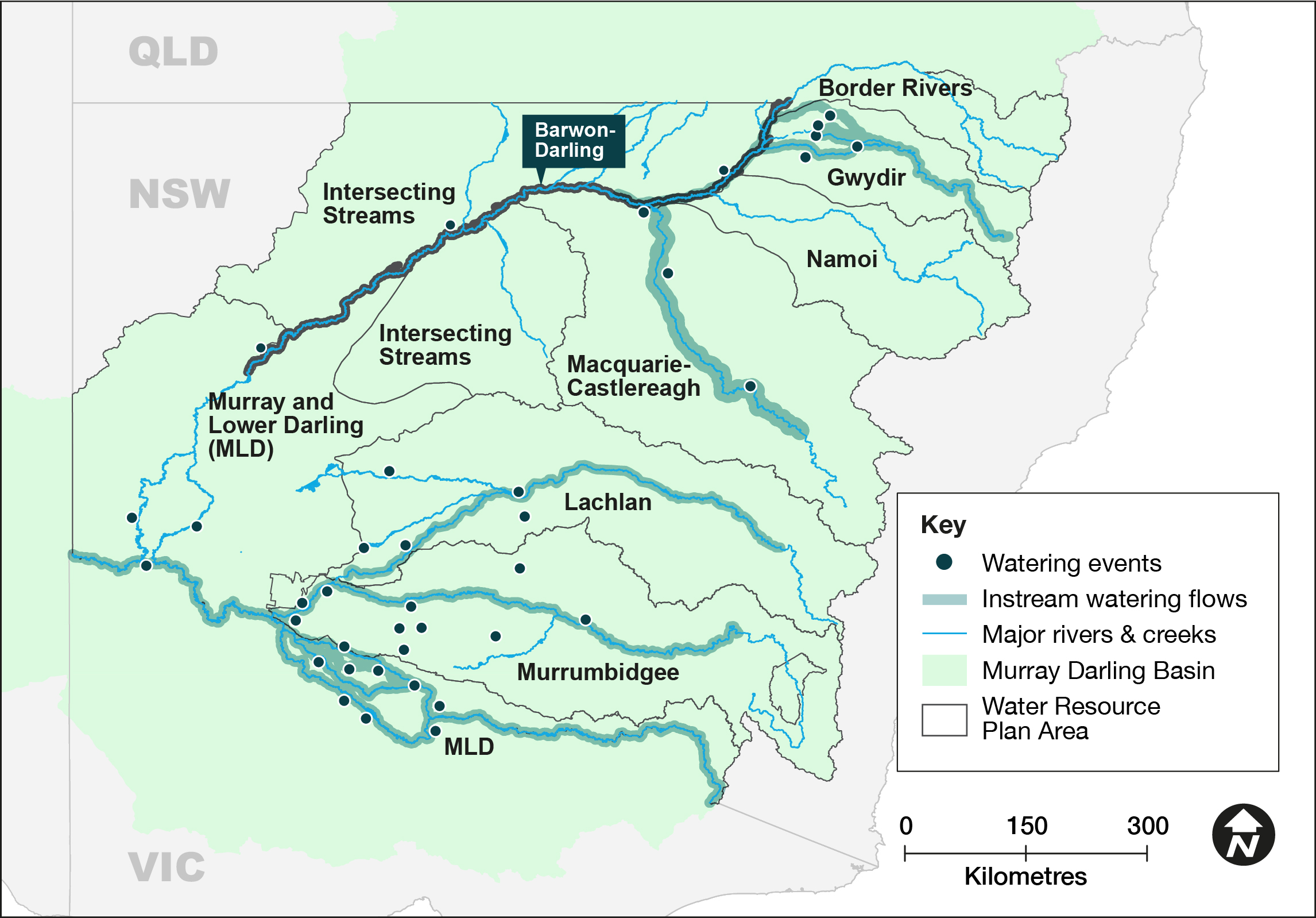
This outcomes report details the work we do in 9 water resource plan areas to support our river systems and meet the needs of native plants, native fish, waterbirds and other water-dependent wildlife:
- Murray and Lower Darling water resource plan area – 447,762.5 megalitres delivered to multiple sites in the Murray and Lower Darling catchments
- Murrumbidgee water resource plan area – 683,668.8 megalitres delivered to multiple wetlands in the Murrumbidgee catchment
- Lachlan water resource plan area – 34,270 megalitres delivered to wetlands, rivers and creeks in the Lachlan catchment
- Macquarie–Castlereagh water resource plan area – 71,512 megalitres delivered to the Macquarie Marshes and Macquarie River
- Gwydir water resource plan area – 50,229 megalitres delivered to watercourses and wetlands in the Gwydir catchment
- Barwon–Darling water resource plan area – 45,697.8 megalitres protected down the Barwon–Darling watercourse
- Border Rivers water resource plan area
- Intersecting Streams water resource plan area
- Namoi water resource plan area.
Visit our Water for the environment webpages for further information on what we do, how we make decisions and how we deliver environmental flows.
Executive summary
Maintaining and restoring the health of rivers and wetlands for future generations is the aim of the Water for the Environment Program. Our adaptive management approach allows us to focus our efforts on outcomes that can be achieved with the water that’s available in any given year.
In 2021–22, the DPE – EHG Water for the Environment team managed the delivery of approximately 1,333,140 megalitres of water across 33 delivery events for the environment. This water for the environment was sourced from NSW, Commonwealth, and joint government water accounts and delivered to key sites across the state.
At the start of the water year, the state was experiencing variable conditions with plans in place to respond where possible. Widespread rainfall and improved dam levels provided an opportunity for the program to target enhanced outcomes at sites across the state.
Teams worked to support restoration of habitat and expand areas of inundation to provide feeding, breeding and movement opportunities for native fish, waterbirds and frogs.
In natural flowing rivers we worked with other water agencies to protect some instream flows to provide benefits for communities and the environment.
We continued our work with NSW community-based environmental water advisory groups to prioritise sites to receive water and build on the successes of previous years. We collaborated with numerous landholders, First Nations and community members across the rivers and floodplains where we work. The support and cooperation of stakeholders is critical to the successful outcomes achieved.
Water was used strategically to:
- support water bird health
- support native fish health
- support native vegetation health
- connect and replenish refuge sites, wetlands and rivers.
Murray and Lower Darling Baaka catchments
In 2021–22 we delivered 448 gigalitres of water to rivers, creeks and wetlands on private and public land. We:
- encouraged the dispersal of golden perch juveniles
- promoted the growth and survival of Murray cod juveniles
- improved conditions for floodplain river red gums that had not received water since 2016
- supported several successful colonial nesting waterbird breeding events
- successfully supported southern bell frog breeding and recruitment at a number of private property wetland sites
- managed more gradual and natural rates of recession behind operational releases to improve fish movement opportunities and minimise riverbank erosion.
Murrumbidgee catchment
In 2021–22 we delivered 684 gigalitres of water to rivers, creeks and wetlands on private and public land. We:
- supported the largest ever pelican rookery documented in the Murrumbidgee catchment
- maintained a highly significant ibis and spoonbill rookery of about 20,000 nests in the Gayini (Nimmie-Caira) wetlands
- mitigated hypoxic blackwater events in summer to avoid fish deaths in the lower Murrumbidgee and mid-Yanco billabong systems.
Lachlan catchment
In 2021–22 we delivered 34 gigalitres of water to rivers, creeks and wetlands on private and public land. We:
- supported more than 15,000 Australian pelican nests to completion
- enhanced natural ecosystem functions from wet catchment conditions by supplementing other flows to maintain connectivity across the extensive lower Lachlan floodplain, including Willandra Creek
- contributed to inundation along the length of Merrowie Creek, including the prolonged inundation of Lake Tarwong to improve vegetation condition.
Macquarie–Castlereagh catchment
In 2021–22 we delivered 72 gigalitres of water to rivers, creeks and wetlands on private and public land. We:
- maintained water levels in colonial waterbird colony sites in the Macquarie Marshes
- slowed event flow recession, reducing risk of bank slumping in the mid-Macquarie River
- supported ongoing inundation within the Macquarie Marshes
- maintained flow connection to the Barwon River.
Gwydir catchment
In 2021–22 we delivered 50 gigalitres of water to rivers, creeks and wetlands on private and public land. We:
- supported colonially nesting waterbirds to complete reproduction cycles
- promoted health and resilience, and fostered reproduction of wetland and floodplain vegetation communities
- increased intra- and inter-valley connectivity.
Barwon–Darling catchment
In 2021–22 we protected 46 gigalitres of water for the environment in the Barwon–Darling. During this water year we worked with partner agencies to protect water for the environment under licences in the early part of the year until rainfall and natural flows arrived to meet the needs of the environment.
Border Rivers catchment
In 2021–22 no deliveries of water for the environment were made. During this water year we monitored the catchment and put plans in place to support environmental outcomes; however, rainfall and natural flows were able to meet the needs of the catchment.
Intersecting Streams catchment
In 2021–22 no deliveries of water for the environment were made. During this water year we worked with partner agencies to coordinate the protection of water for the environment in the Intersecting Streams catchment to:
- help sustain waterbird breeding colonies at Narran Lakes
- improve system connectivity between the Condamine–Balonne and the connected Culgoa–Birrie–Bokhara–Narran system
- improve the condition of wetland vegetation at Narran Lakes
- inundate a significant area of the western floodplain at Toorale National Park and State Conservation Area and provide connection from the Warrego to the Darling River
- inundate significant areas of wetlands along the Paroo River.
Namoi catchment
In 2021–22 no deliveries of water for the environment were made. During this water year we:
- adopted a ‘watching brief’ to identify whether intervention with environmental flows would be required
- observed movement of native fish as natural flows provided unrestricted passage along the Namoi and Peel rivers
- monitored connectivity between the Peel, Namoi and Barwon rivers.
Monitoring, evaluation and reporting update
The Water for the Environment Program’s monitoring, evaluating and reporting (MER) projects measure ecological outcomes using indicators of river and wetland health across 4 major environmental themes:
- river flows and connectivity
- native vegetation
- waterbirds
- frogs.
By monitoring these indicators and evaluating the outcomes against planned targets, we can measure progress towards meeting long-term water plan objectives and the goals of the Basin Plan. We are also able to continually improve how we deliver water for the environment to meet those objectives by increasing our understanding of how river and wetland systems respond to flow and flooding regimes.
We track changes in the inundation regimes of floodplain wetlands, vegetation condition (plant community composition), and changes in waterbird and frog populations in response to water regimes. Our monitoring efforts focus on wetlands targeted by water for the environment, including the Gwydir Wetlands, Macquarie Marshes, Lower Lachlan Wetlands, Lowbidgee Floodplain and Millewa Forest. We have also extended our monitoring efforts to the Snowy River, in partnership with the Department of Planning and Environment.
A variety of methods are used to monitor environmental indicators, including:
- satellite imagery to track floodplain wetland inundation
- aerial and ground surveys of waterbird populations
- on-ground surveys of plant species composition
- acoustic recordings and observation to monitor frogs.
We work with the Commonwealth Environmental Water Holder (CEWH) to collaborate with their MER providers including independent researchers, tertiary institutions, and community groups to improve our understanding through complementary monitoring programs.
Our findings are reported to the Murray–Darling Basin Authority to meet Schedule 12 requirements of the Basin Plan. Schedule 12 includes annual reporting of ecological outcomes at an asset-scale (Matter 9.3) and a 5-yearly evaluation (Matter 8) due in 2024.
We also provide regular updates to the community through our website and stakeholder engagement.
An independent evaluation of our Water for the Environment MER Program between 2014 and 2019 has also been completed.
The year in review
2021–22 was a wet year with widespread rainfall across the NSW Murray–Darling Basin. Increased storage levels enabled water for the environment to be delivered to river and wetland habitats across the state to strategically support river flow connections and inundation of wetlands, native vegetation health, waterbird and frog breeding and native fish health.
River flows and connectivity
In 2021–22 natural river flows inundated extensive areas of floodplain, including critical flood-dependent habitats of non-woody wetlands, shrublands such as lignum, as well as the forest and woodland communities of river red gum, coolibah and black box. This included:
- Gwydir wetlands: (including Mallowa Creek and Mehi River) almost 170,000 hectares were inundated in total including 51% (51,300 hectares (ha)) of flood-dependent habitat.
- Macquarie Marshes: 193,100 hectares were inundated including 93% (99,700 ha) of flood-dependent habitat.
- Lower Lachlan: 98,700 hectares were inundated including 34% (96,700 ha) of flood-dependent habitat.
- Lowbidgee floodplain: 130,200 hectares were inundated including 54% (94,950 ha) of flood-dependent habitat.
- Millewa Forest: 16,500 hectares were inundated including 48% (16,380 ha) of flood-dependent habitat.
The increased area of wetland habitat availability supported waterbird and frog breeding.
Waterbird surveys
Triggered by widespread wet conditions during spring–summer 2021–22, the most extensive colonial waterbird breeding event in more than a decade unfolded across the NSW Murray–Darling Basin.
At least 14 waterbird species established more than 80 individual breeding colonies, with more than 250,000 nests across 6 major wetland complexes in the Macquarie, Narran, Gwydir, Lachlan, Lowbidgee and mid-Murray. The 2021–22 water year was a critical season for breeding, with monitoring by the long-term Eastern Australian Waterbird Survey indicating ongoing decline of populations across many waterbird species.
The extensive colonial waterbird breeding event dominated the waterbird monitoring effort across the department. Water levels were actively managed by environmental water managers to support reproductive success. Colonies were monitored by the department using on-ground and aerial methods under scientific and ethics approvals. We worked with the CEWH, Flow-MER program providers, University of NSW, Local Land Services and private landholders. Monitoring included nest and species counts, colony health and water monitoring.
The Gwydir had its largest breeding event since 2011–12 with 45,000 nests from 14 species supported through to fledging. In Narran Lakes, 10,000 nests were recorded from 12 colonial nesting waterbird species including straw-necked ibis, royal spoonbill, little pied cormorants and Australasian darter.
The Macquarie Marshes saw large-scale waterbird colonies of over 90,000 nests, including 3 ibis colonies of up to 40,000 nests each, as well as several large-scale (5,000+ nests) night heron and egret colonies in river red gum forests.
In the Lachlan more than 30,000 adult pelicans nested at Lake Brewster and successfully reproduced to fledglings, making this the largest breeding event in more than 30 years.
Across the Lowbidgee floodplain more than 20,000 straw-necked ibis and royal spoonbills nested in the Gayini (Nimmie-Caira) wetland system and about 15,000 pelicans nested in Kieeta Lake. Targeted surveys of the endangered Australasian bittern and Australian little bittern were completed in the Lowbidgee during the 2021–22 breeding season, with booming activity concentrated to only a couple of sites.
In the mid-Murray there were about 1,500 colonial waterbird nests.
Intensive monitoring of waterbird breeding colony sites is vital for seasonal adaptive management of environmental water deliveries. Data from this infrequent event contributes to the long-term data record, which is necessary to evaluate our progress towards meeting long-term targets. The aim of these targets is to arrest the decline of waterbirds across the Murray–Darling Basin.
Frog surveys
During the 2021–22 spring-summer, natural inflows and the delivery of water for the environment provided wetland habitat for frogs and supported frog breeding across many monitored sites.
In the Gwydir catchment, 11 frog species were detected, including 6 flow-dependent frog species: spotted marsh frogs, eastern sign-bearing froglets, barking marsh frogs, Peron’s tree frogs, broad-palmed frogs, and salmon-striped frogs. Frog breeding was widespread by spring and continued to November for barking marsh and spotted marsh frogs. The wet conditions in November also prompted rain-responding species out of their refuges for breeding. Three burrowing frog species, the striped burrowing frog, knife-footed and water-holding frog, were detected as well as the tree-dwelling green tree frog and desert tree frog.
Surveys in the Macquarie Marshes detected 8 frog species and high levels of frog breeding success. Six flow-dependent species, the spotted marsh frog, barking marsh frog, Eastern sign-bearing froglet, Peron’s tree frog, broad-palmed frog and salmon-striped frog, as well as the tree-dwelling green tree frog and desert tree frog were detected.
The Lower Lachlan was once a refuge for the endangered southern bell frog. The species was detected in 2021 for the first time since 2012. The Saving our Species Team surveyed 21 wetland sites in the lower Lachlan area during the spring of 2021–22 to gain baseline knowledge of southern bell frog distribution in the region. Surveys included the Great Cumbung Swamp region and primarily used acoustic recorders. Southern bell frog numbers appeared to be relatively low at most sites, with the exception of Dry Lake and Lignum Lake. Higher numbers were recorded at sites nearer to the Murrumbidgee region. It’s thought the frogs may have migrated north during wet conditions when parts of the Murrumbidgee River were in flood. Ongoing monitoring will be key to determining the species’ persistence and defining targeted watering strategies.
In the Murrumbidgee Saving our Species staff, in partnership with the CEWH, Coleambally Irrigation and private landholders, conducted surveys for the southern bell frog. Hundreds of southern bell frogs were detected at some sites.
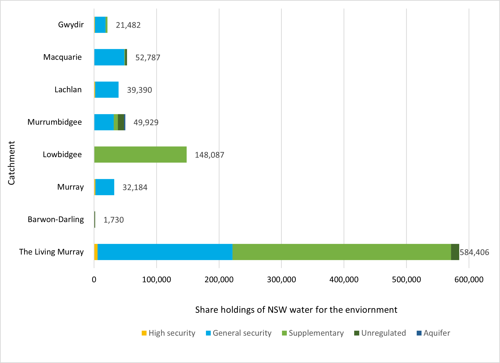
Water holdings and trade
The Department of Planning and Environment is the lead agency for the delivery of water for the environment in New South Wales. This includes collaboration on the delivery of Commonwealth water held by the Commonwealth Environment Water Holder.
This chart summarises current water holdings, or state ‘held’ water for the environment, recovered to 30 June 2022 (megalitres).
Water trade
The department uses the water market to:
- move water to where it is needed most
- help pay water-use licence fees
- support small infrastructure projects to improve environmental outcomes.
Trades typically commit less than 5% of the water available to the environment and are a small proportion of the total trades made by other market participants.
In 2021–22 a total net volume of 11,085 megalitres of surface water was sold across all catchments, with 6,575 megalitres purchased upstream of the Barmah Choke, funded by sales downstream of the choke. An additional 4,000 megalitres of Murrumbidgee ‘event based’ supplementary water was sold in 2021–22.
More information about water trade announcements and reporting is available.
Partners
We work with a range of partner agencies, organisations and individuals to achieve/secure effective and efficient delivery of water to our rivers and wetlands.
These include:
- Department of Primary Industries – Fisheries
- Department of Planning and Environment
- Southern Connected Basin Environmental Water Committee
- Northern Basin Aboriginal Nations
- Environmental Water Advisory Groups
- First Nations peoples
- Murray Lower Darling Rivers Indigenous Nations
- landholders
- recreational fishers
- universities
- Murray–Darling Basin Authority
- Commonwealth Environmental Water Holder.
More information about some of our partner agencies is available on our terms and definitions webpage.